IMAGES TAKEN NEAR TO
Langholme Lane, DONCASTER, DN9 2EU
Introduction
This page details the photographs taken nearby to Langholme Lane, DN9 2EU by members of the Geograph project.
The Geograph project started in 2005 with the aim of publishing, organising and preserving representative images for every square kilometre of Great Britain, Ireland and the Isle of Man.

There are currently over 7.5m images from over14,400 individuals and you can help contribute to the project by visiting https://www.geograph.org.uk
Image Map
Images are licensed for reuse under creativecommons.org/licenses/by-sa/2.0
Notes
- Clicking on the map will re-center to the selected point.
- The higher the marker number, the further away the image location is from the centre of the postcode.
Image Listing (11 Images Found)
Images are licensed for reuse under creativecommons.org/licenses/by-sa/2.0
Image
Details
Distance
5

Level Crossing near Westwoodside
Unmanned crossing on the Doncaster to Gainsborough line.
Image: © Jonathan Clitheroe
Taken: 22 Feb 2016
0.15 miles
7
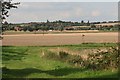
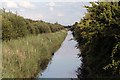
Warping Drain
Many of these drains were constructed by the Dutchman Cornelius Vermuyden in the 17th century. He demonstrated how flooding of the tidal Trent could be used to deposit 'warp' (fertile sediment) onto the land.
Image: © Tim Heaton
Taken: 24 Jul 2015
0.16 miles
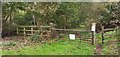
8
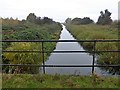
Plenty of water in the drain
Looking east off the public footbridge over the drain.
Image: © roger geach
Taken: 7 Aug 2009
0.19 miles
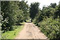
9
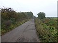
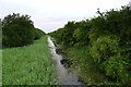
Footpath and farm track beside Langholme Wood
Image: © Graham Hogg
Taken: 24 Oct 2019
0.20 miles