IMAGES TAKEN NEAR TO
Pelfintax, DONCASTER, DN9 2EL
Introduction
This page details the photographs taken nearby to Pelfintax, DN9 2EL by members of the Geograph project.
The Geograph project started in 2005 with the aim of publishing, organising and preserving representative images for every square kilometre of Great Britain, Ireland and the Isle of Man.

There are currently over 7.5m images from over14,400 individuals and you can help contribute to the project by visiting https://www.geograph.org.uk
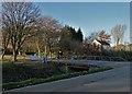
Image Map
Images are licensed for reuse under creativecommons.org/licenses/by-sa/2.0
Notes
- Clicking on the map will re-center to the selected point.
- The higher the marker number, the further away the image location is from the centre of the postcode.
Image Listing (11 Images Found)
Images are licensed for reuse under creativecommons.org/licenses/by-sa/2.0
Image
Details
Distance
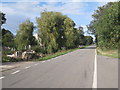
4
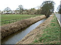
Drain beside Idle Bank
Looking north near Bull Hassocks Farm.
Image: © JThomas
Taken: 28 Feb 2015
0.11 miles
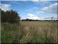
5
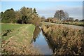
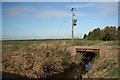
South Idle Drain
Idle Bank and South Idle Drain near Westwoodside
Image: © Richard Croft
Taken: 9 Nov 2009
0.15 miles
6
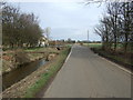
Idle Bank
Heading north near Bull Hassocks Farm.
Image: © JThomas
Taken: 28 Feb 2015
0.21 miles
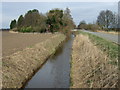
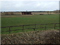
9
Westwoodside Carrs
Agricultural bridge over South Idle Drain on Idle Bank
Image: © Richard Croft
Taken: 9 Nov 2009
0.23 miles