IMAGES TAKEN NEAR TO
Doncaster Road, DONCASTER, DN9 2EH
Introduction
This page details the photographs taken nearby to Doncaster Road, DN9 2EH by members of the Geograph project.
The Geograph project started in 2005 with the aim of publishing, organising and preserving representative images for every square kilometre of Great Britain, Ireland and the Isle of Man.

There are currently over 7.5m images from over14,400 individuals and you can help contribute to the project by visiting https://www.geograph.org.uk
Image Map
Images are licensed for reuse under creativecommons.org/licenses/by-sa/2.0
Notes
- Clicking on the map will re-center to the selected point.
- The higher the marker number, the further away the image location is from the centre of the postcode.
Image Listing (12 Images Found)
Images are licensed for reuse under creativecommons.org/licenses/by-sa/2.0
Image
Details
Distance
1
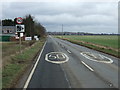
Doncaster Road (B1396) towards Westwoodside
Heading north east.
Image: © JThomas
Taken: 28 Feb 2015
0.03 miles
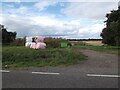
3
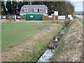
Park Drain
Beside Doncaster Road (B1396) - looking east.
Image: © JThomas
Taken: 28 Feb 2015
0.06 miles
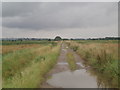
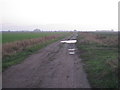
4
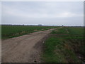
Footpath to Fountain Farm
This footpath leads from the B1396 over the very flat fields and a level crossing to Fountain Farm.
Image: © Michael Patterson
Taken: 27 Mar 2006
0.11 miles
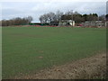
5
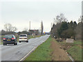
Doncaster Road near Westwoodside
Looking towards Levels Farm.
Image: © Alan Murray-Rust
Taken: 13 Mar 2011
0.13 miles
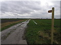
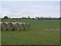
7
Broomston Lane
Provides farm access and a footpath to Broomston.
Image: © Jonathan Thacker
Taken: 19 Nov 2011
0.16 miles
8
View from Doncaster Road
Looking across to Pelf Intax and Idle Bank.
Image: © Alan Murray-Rust
Taken: 13 Mar 2011
0.17 miles