IMAGES TAKEN NEAR TO
Doncaster Road, DONCASTER, DN9 2EE
Introduction
This page details the photographs taken nearby to Doncaster Road, DN9 2EE by members of the Geograph project.
The Geograph project started in 2005 with the aim of publishing, organising and preserving representative images for every square kilometre of Great Britain, Ireland and the Isle of Man.

There are currently over 7.5m images from over14,400 individuals and you can help contribute to the project by visiting https://www.geograph.org.uk
Image Map
Images are licensed for reuse under creativecommons.org/licenses/by-sa/2.0
Notes
- Clicking on the map will re-center to the selected point.
- The higher the marker number, the further away the image location is from the centre of the postcode.
Image Listing (17 Images Found)
Images are licensed for reuse under creativecommons.org/licenses/by-sa/2.0
Image
Details
Distance
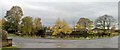
2
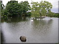
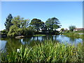
Village Pond
Westwoodside village pond
Image: © Richard Croft
Taken: 8 Sep 2005
0.12 miles
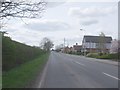
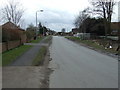
4
Commonside, Westwoodside
Looking south east.
Image: © JThomas
Taken: 28 Feb 2015
0.18 miles
6
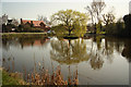
Village pond
Pond at Westwoodside http://www.geograph.org.uk/photo/50920
Image: © Richard Croft
Taken: 28 Mar 2012
0.21 miles
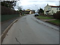
8

Village pond at Westwoodside.
A lovely village to walk through.
Image: © steven ruffles
Taken: 3 Nov 2022
0.21 miles
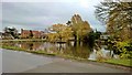
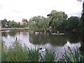
10
The village pond at Westwoodside
The village pond is between Cove Road and Commonside from where this photograph was taken. The pond is the main feature on the village sign - see https://www.geograph.org.uk/photo/6264228
Image: © Marathon
Taken: 8 Sep 2019
0.21 miles