IMAGES TAKEN NEAR TO
Firth Lane, DONCASTER, DN9 2BW
Introduction
This page details the photographs taken nearby to Firth Lane, DN9 2BW by members of the Geograph project.
The Geograph project started in 2005 with the aim of publishing, organising and preserving representative images for every square kilometre of Great Britain, Ireland and the Isle of Man.

There are currently over 7.5m images from over14,400 individuals and you can help contribute to the project by visiting https://www.geograph.org.uk
Image Map
Images are licensed for reuse under creativecommons.org/licenses/by-sa/2.0
Notes
- Clicking on the map will re-center to the selected point.
- The higher the marker number, the further away the image location is from the centre of the postcode.
Image Listing (24 Images Found)
Images are licensed for reuse under creativecommons.org/licenses/by-sa/2.0
Image
Details
Distance


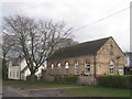
6
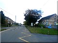
Field Lane in Wroot
The village primary school is on the right of picture.
Image: © Jonathan Clitheroe
Taken: 17 Oct 2016
0.08 miles

8
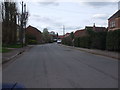
Village street, Wroot
Looking along part of the High Street. Wroot is a village mainly in the form of ribbon development along the lane.
Image: © Andrew Hill
Taken: 16 Aug 2010
0.09 miles
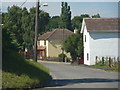
10
Wroot School
One of the few worthwhile buildings in the village.
Image: © Jonathan Thacker
Taken: 3 Apr 2011
0.09 miles