IMAGES TAKEN NEAR TO
Wroot, DONCASTER, DN9 2BH
Introduction
This page details the photographs taken nearby to DN9 2BH by members of the Geograph project.
The Geograph project started in 2005 with the aim of publishing, organising and preserving representative images for every square kilometre of Great Britain, Ireland and the Isle of Man.

There are currently over 7.5m images from over14,400 individuals and you can help contribute to the project by visiting https://www.geograph.org.uk
Image Map
Images are licensed for reuse under creativecommons.org/licenses/by-sa/2.0
Notes
- Clicking on the map will re-center to the selected point.
- The higher the marker number, the further away the image location is from the centre of the postcode.
Image Listing (17 Images Found)
Images are licensed for reuse under creativecommons.org/licenses/by-sa/2.0
Image
Details
Distance
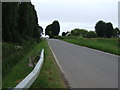
3

Thorn Bank
A road sign leans towards North Thorn Bank Drain as many signs do hereabouts.
Image: © Richard Croft
Taken: 28 Mar 2012
0.05 miles
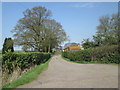
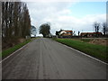
4
By Thorn Bank, near Wroot
Going by the map, these houses are Thorn Cottages maybe built as farm workers' homes for the adjacent Thorn Cottage Farm
Image: © Paul Harrop
Taken: 25 Oct 2016
0.05 miles
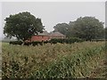
8
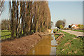
South Idle Drain
Drain beside Idle Bank with a fallen poplar from Thorn Cottage Farm
Image: © Richard Croft
Taken: 28 Mar 2012
0.14 miles
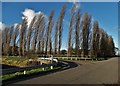
9
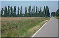
Idle Bank and trees by Thorn Bank
Looking north to the line of poplars lining the lane to Wroot.
Image: © Andrew Hill
Taken: 16 Aug 2010
0.14 miles
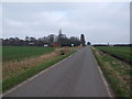
10
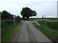
Junction of Thorn Bank with Idle Bank
Looking east.
Image: © JThomas
Taken: 28 Jun 2014
0.15 miles