IMAGES TAKEN NEAR TO
Cove Road, DONCASTER, DN9 2BA
Introduction
This page details the photographs taken nearby to Cove Road, DN9 2BA by members of the Geograph project.
The Geograph project started in 2005 with the aim of publishing, organising and preserving representative images for every square kilometre of Great Britain, Ireland and the Isle of Man.

There are currently over 7.5m images from over14,400 individuals and you can help contribute to the project by visiting https://www.geograph.org.uk
Image Map
Images are licensed for reuse under creativecommons.org/licenses/by-sa/2.0
Notes
- Clicking on the map will re-center to the selected point.
- The higher the marker number, the further away the image location is from the centre of the postcode.
Image Listing (9 Images Found)
Images are licensed for reuse under creativecommons.org/licenses/by-sa/2.0
Image
Details
Distance
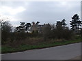
3
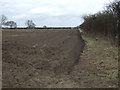
Bridleway to the Bank
This bridleway crosses low lying fields on Greenholme Bank. Image
Image: © Michael Patterson
Taken: 30 Oct 2006
0.16 miles
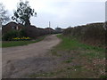
6
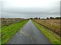
Cove quarry access road
This private road, which leads to a sand quarry and a farm, has been constructed to a high standard.
Image: © Graham Hogg
Taken: 21 Nov 2017
0.20 miles
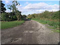
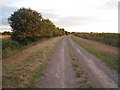
7
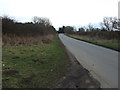
Cove Road
Heading south east towards Westwoodside.
Image: © JThomas
Taken: 28 Feb 2015
0.21 miles
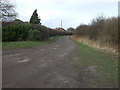
8
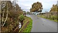
Electric security gate on private road near Westmoorside
The well maintained road is also a bridleway alongside a lake formed in old sand pit workings.
The ditch is as well maintained as the road.
Image: © Chris Morgan
Taken: 21 Nov 2017
0.23 miles
9
Track near Westwoodside
Although not marked as an official right of way, a notice at the beginning of this track states that it is for use as a footpath and for horses.
Image: © Jonathan Thacker
Taken: 29 Jul 2010
0.25 miles