IMAGES TAKEN NEAR TO
Owston Ferry, DONCASTER, DN9 1TZ
Introduction
This page details the photographs taken nearby to DN9 1TZ by members of the Geograph project.
The Geograph project started in 2005 with the aim of publishing, organising and preserving representative images for every square kilometre of Great Britain, Ireland and the Isle of Man.

There are currently over 7.5m images from over14,400 individuals and you can help contribute to the project by visiting https://www.geograph.org.uk
Image Map
Images are licensed for reuse under creativecommons.org/licenses/by-sa/2.0
Notes
- Clicking on the map will re-center to the selected point.
- The higher the marker number, the further away the image location is from the centre of the postcode.
Image Listing (8 Images Found)
Images are licensed for reuse under creativecommons.org/licenses/by-sa/2.0
Image
Details
Distance
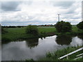
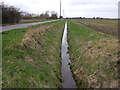
2
Power lines reflected
The Warping Drain at Owston Ferry Road.
Image: © Alan Murray-Rust
Taken: 13 Mar 2011
0.19 miles
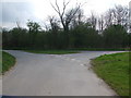
6
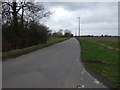
Lound Road
Heading west towards Graizelound.
Image: © JThomas
Taken: 28 Feb 2015
0.23 miles
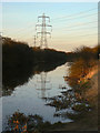
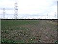
7
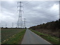
Power lines crossing Owston Ferry Road
Looking south west.
Image: © JThomas
Taken: 28 Feb 2015
0.24 miles
8
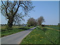
Carr Lane
Looking north towards East Lound.
Image: © David Squire
Taken: 10 May 2006
0.24 miles