IMAGES TAKEN NEAR TO
Wheatfield Close, DONCASTER, DN9 1SY
Introduction
This page details the photographs taken nearby to Wheatfield Close, DN9 1SY by members of the Geograph project.
The Geograph project started in 2005 with the aim of publishing, organising and preserving representative images for every square kilometre of Great Britain, Ireland and the Isle of Man.

There are currently over 7.5m images from over14,400 individuals and you can help contribute to the project by visiting https://www.geograph.org.uk
Image Map
Images are licensed for reuse under creativecommons.org/licenses/by-sa/2.0
Notes
- Clicking on the map will re-center to the selected point.
- The higher the marker number, the further away the image location is from the centre of the postcode.
Image Listing (12 Images Found)
Images are licensed for reuse under creativecommons.org/licenses/by-sa/2.0
Image
Details
Distance
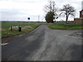
1
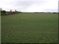
Crop field near Epworth
North of Rectory Street.
Image: © JThomas
Taken: 28 Feb 2015
0.12 miles
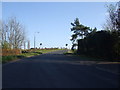
2
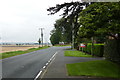
Rectory Street
At its junction with Newlands Lane at the eastern edge of the town
Image: © Graham Hogg
Taken: 8 Sep 2015
0.17 miles
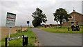
3
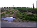
Footpath to Epworth
The countryside has many footpaths in this area.
Image: © Andy Beecroft
Taken: 25 Aug 2006
0.18 miles
4
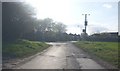
Junction of Newland Lane and Melwood Hill
Image: © Glyn Drury
Taken: 1 Apr 2009
0.18 miles
5
Road junction on the outskirts of Epworth
Rectory Street meets Newlands Lane - looking east.
Image: © JThomas
Taken: 28 Feb 2015
0.18 miles

7
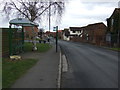
Bus stop and shelter on Rectory Street, Epworth
Looking east.
Image: © JThomas
Taken: 28 Feb 2015
0.19 miles
8
Corner of Newlands Lane with Melwood Hill
Image: © Chris Morgan
Taken: 8 Sep 2015
0.20 miles
10

Fields of oilseed rape near Epworth
A colourful scene.
Image: © steven ruffles
Taken: 16 May 2016
0.23 miles