IMAGES TAKEN NEAR TO
South Street, DONCASTER, DN9 1RP
Introduction
This page details the photographs taken nearby to South Street, DN9 1RP by members of the Geograph project.
The Geograph project started in 2005 with the aim of publishing, organising and preserving representative images for every square kilometre of Great Britain, Ireland and the Isle of Man.

There are currently over 7.5m images from over14,400 individuals and you can help contribute to the project by visiting https://www.geograph.org.uk
Image Map
Images are licensed for reuse under creativecommons.org/licenses/by-sa/2.0
Notes
- Clicking on the map will re-center to the selected point.
- The higher the marker number, the further away the image location is from the centre of the postcode.
Image Listing (98 Images Found)
Images are licensed for reuse under creativecommons.org/licenses/by-sa/2.0
Image
Details
Distance
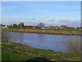
1
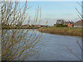
River Trent at Owston Ferry
Looking across from the bank at South Street.
Image: © Alan Murray-Rust
Taken: 13 Mar 2011
0.04 miles
2
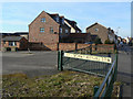
Entrance to Trent Farm
This picture is not reversed. The lettering is cut out from a metal plate and is seen here from the rear. For a view of the farm see http://www.geograph.org.uk/photo/2310563 .
Image: © Alan Murray-Rust
Taken: 13 Mar 2011
0.05 miles
3
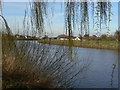
River Trent at Owston Ferry
Looking across from the bank at South Street.
Image: © Alan Murray-Rust
Taken: 13 Mar 2011
0.05 miles
4
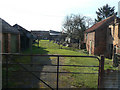
Farmyard on South Street
This has clearly not been in regular use for some time.
Image: © Alan Murray-Rust
Taken: 13 Mar 2011
0.07 miles
5
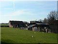
Farmyard on South Street
The buildings are beginning to look derelict.
Image: © Alan Murray-Rust
Taken: 13 Mar 2011
0.07 miles
6
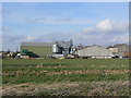
Trent Farm
The modern appearance of farming. The installation in the centre of the picture is for drying grain.
Image: © Alan Murray-Rust
Taken: 13 Mar 2011
0.08 miles
7
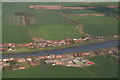
Owston Ferry and East Ferry: aerial 2013
Looking east across the River Trent.
Warping Drain and the pumping station are on the right.
Image: © Chris
Taken: 5 May 2013
0.08 miles
8

Steam pumping engine, Owston Ferry
The survivor of two Marshall horizontal tandem compound drop valve engines. A very fine example preserved by the drainage authority.
Image: © Chris Allen
Taken: 15 Mar 1987
0.09 miles
9
East Ferry
Seen across the River Trent from the riverside walk along South Street, Owston Ferry. As the name implies, it was once the part of the village on the east side of the ferry. With the ferry defunct, you now have to go to either Keadby or Gainsborough to cross the river, a distance of 18 or 21 miles!
Image: © Alan Murray-Rust
Taken: 13 Mar 2011
0.09 miles
10
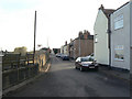
South Street, Owston Ferry
Looking south from The Crooked Billet.
Image: © Alan Murray-Rust
Taken: 13 Mar 2011
0.09 miles