IMAGES TAKEN NEAR TO
Westgate Road, DONCASTER, DN9 1QB
Introduction
This page details the photographs taken nearby to Westgate Road, DN9 1QB by members of the Geograph project.
The Geograph project started in 2005 with the aim of publishing, organising and preserving representative images for every square kilometre of Great Britain, Ireland and the Isle of Man.

There are currently over 7.5m images from over14,400 individuals and you can help contribute to the project by visiting https://www.geograph.org.uk
Image Map
Images are licensed for reuse under creativecommons.org/licenses/by-sa/2.0
Notes
- Clicking on the map will re-center to the selected point.
- The higher the marker number, the further away the image location is from the centre of the postcode.
Image Listing (24 Images Found)
Images are licensed for reuse under creativecommons.org/licenses/by-sa/2.0
Image
Details
Distance
1
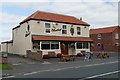
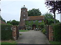
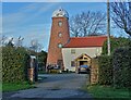
The Wheatsheaf
Recently refurbished pub on Westgate Road
Image: © Graham Hogg
Taken: 8 Sep 2015
0.03 miles
3
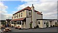
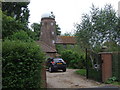
The Wheatsheaf, 1707
Not sure if 1707 is the original date of this building, or an older one on the same site. Apparently a total renovation was completed this year (2015).
Image: © Chris Morgan
Taken: 8 Sep 2015
0.04 miles
4
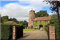
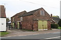
The Wheatsheaf undergoing extensive remodelling
Image: © Chris
Taken: 30 Mar 2014
0.04 miles
5
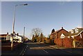
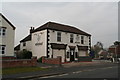
Westgate Road Westgate Isle of Axholme
Image: © Steve Fareham
Taken: 10 Jan 2015
0.11 miles
6
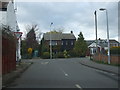
Junction of Carrhouse Road and Westgate Road
Image: © Glyn Drury
Taken: 30 Mar 2009
0.13 miles