IMAGES TAKEN NEAR TO
High Street, DONCASTER, DN9 1NS
Introduction
This page details the photographs taken nearby to High Street, DN9 1NS by members of the Geograph project.
The Geograph project started in 2005 with the aim of publishing, organising and preserving representative images for every square kilometre of Great Britain, Ireland and the Isle of Man.

There are currently over 7.5m images from over14,400 individuals and you can help contribute to the project by visiting https://www.geograph.org.uk
Image Map
Images are licensed for reuse under creativecommons.org/licenses/by-sa/2.0
Notes
- Clicking on the map will re-center to the selected point.
- The higher the marker number, the further away the image location is from the centre of the postcode.
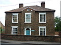
Image Listing (32 Images Found)
Images are licensed for reuse under creativecommons.org/licenses/by-sa/2.0
Image
Details
Distance
4
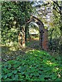
A curious arch in Belton churchyard
My best attempts to discover the history of this arch have been thwarted. I wonder if it came from a grand country house called Temple Belwood which was demolished during the construction of the M180 motorway in the 1970's.
Image: © Neil Theasby
Taken: 12 Nov 2020
0.10 miles
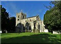
6
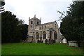
Church of All Saints, Belton
Part of Church Town, Belton
Image: © Tim Heaton
Taken: 23 Oct 2015
0.11 miles
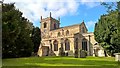
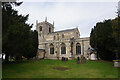
9
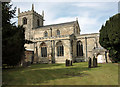
All Saints Church, Belton
Taken on the occasion of the 2011 Flower Festival.
Image: © Peter Church
Taken: 9 Sep 2011
0.12 miles