IMAGES TAKEN NEAR TO
Beltoft, DONCASTER, DN9 1NF
Introduction
This page details the photographs taken nearby to DN9 1NF by members of the Geograph project.
The Geograph project started in 2005 with the aim of publishing, organising and preserving representative images for every square kilometre of Great Britain, Ireland and the Isle of Man.

There are currently over 7.5m images from over14,400 individuals and you can help contribute to the project by visiting https://www.geograph.org.uk
Image Map
Images are licensed for reuse under creativecommons.org/licenses/by-sa/2.0
Notes
- Clicking on the map will re-center to the selected point.
- The higher the marker number, the further away the image location is from the centre of the postcode.
Image Listing (4 Images Found)
Images are licensed for reuse under creativecommons.org/licenses/by-sa/2.0
Image
Details
Distance
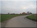
2
Farm buildings off Cloud's Lane
New buildings have gone up since Steve F's picture of March 2008 Image
Image: © Jonathan Thacker
Taken: 2 Mar 2011
0.11 miles
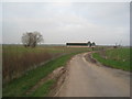
3
Old road tanker and farm building off Clouds Lane near Beltoft
On the horizon sunlight is lighting the town of Scunthorpe.
Image: © Steve Fareham
Taken: 2 Mar 2008
0.12 miles
4
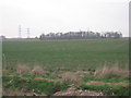
View towards Gravel Hill Wood from Sand Road
Image: © Jonathan Thacker
Taken: 2 Mar 2011
0.24 miles