IMAGES TAKEN NEAR TO
High Street, DONCASTER, DN9 1LR
Introduction
This page details the photographs taken nearby to High Street, DN9 1LR by members of the Geograph project.
The Geograph project started in 2005 with the aim of publishing, organising and preserving representative images for every square kilometre of Great Britain, Ireland and the Isle of Man.

There are currently over 7.5m images from over14,400 individuals and you can help contribute to the project by visiting https://www.geograph.org.uk
Image Map
Images are licensed for reuse under creativecommons.org/licenses/by-sa/2.0
Notes
- Clicking on the map will re-center to the selected point.
- The higher the marker number, the further away the image location is from the centre of the postcode.
Image Listing (29 Images Found)
Images are licensed for reuse under creativecommons.org/licenses/by-sa/2.0
Image
Details
Distance
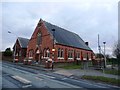
4
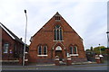
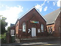
Methodist Church, Belton
With a date stone for 1879
Image: © Tim Heaton
Taken: 23 Oct 2015
0.05 miles
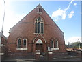
7
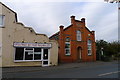
Public Hall, Belton
Apparently a former Wesleyan Chapel, altered to a public hall in 1883.
Image: © Tim Heaton
Taken: 23 Oct 2015
0.14 miles
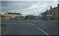
8
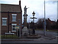
War Memorial, Belton
This unusual war memorial and signpost cum lamppost are to be found on the south east quadrant of the cross roads at Belton.
Image: © David Squire
Taken: 21 Mar 2006
0.14 miles
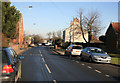
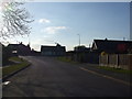
10
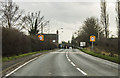
A161 approaching Belton
Junction with King Edward St and Westgate road ahead.
Image: © J.Hannan-Briggs
Taken: 26 Dec 2015
0.15 miles