IMAGES TAKEN NEAR TO
Shepherds Croft, DONCASTER, DN9 1LH
Introduction
This page details the photographs taken nearby to Shepherds Croft, DN9 1LH by members of the Geograph project.
The Geograph project started in 2005 with the aim of publishing, organising and preserving representative images for every square kilometre of Great Britain, Ireland and the Isle of Man.

There are currently over 7.5m images from over14,400 individuals and you can help contribute to the project by visiting https://www.geograph.org.uk
Image Map
Images are licensed for reuse under creativecommons.org/licenses/by-sa/2.0
Notes
- Clicking on the map will re-center to the selected point.
- The higher the marker number, the further away the image location is from the centre of the postcode.
Image Listing (7 Images Found)
Images are licensed for reuse under creativecommons.org/licenses/by-sa/2.0
Image
Details
Distance
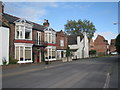
1
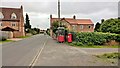
West End Road, Epworth
Phone box and pillar box. The phone box may be on its last legs, the post box may have a future.
Image: © Chris Morgan
Taken: 8 Sep 2015
0.12 miles
4
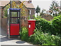
Public telephone Box
With a Post Box for company
Image: © Siobhan Brennan-Raymond
Taken: 31 May 2007
0.18 miles
5
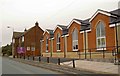
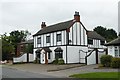
Epworth Baptist Church
On Station Road.
Image: © Steve Fareham
Taken: 20 Dec 2008
0.21 miles