IMAGES TAKEN NEAR TO
Blow Row, DONCASTER, DN9 1HP
Introduction
This page details the photographs taken nearby to Blow Row, DN9 1HP by members of the Geograph project.
The Geograph project started in 2005 with the aim of publishing, organising and preserving representative images for every square kilometre of Great Britain, Ireland and the Isle of Man.

There are currently over 7.5m images from over14,400 individuals and you can help contribute to the project by visiting https://www.geograph.org.uk
Image Map
Images are licensed for reuse under creativecommons.org/licenses/by-sa/2.0
Notes
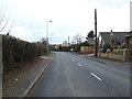
- Clicking on the map will re-center to the selected point.
- The higher the marker number, the further away the image location is from the centre of the postcode.
Image Listing (71 Images Found)
Images are licensed for reuse under creativecommons.org/licenses/by-sa/2.0
Image
Details
Distance
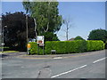
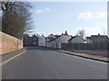
2
Burnham Road, Epworth (A161)
Looking north.
Image: © JThomas
Taken: 28 Feb 2015
0.09 miles
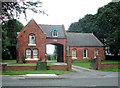
3
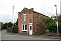
Yet another chapel in Epworth
You could easily miss this tiny former chapel in Chapel Street.
Image: © Chris
Taken: 4 Aug 2013
0.13 miles

7
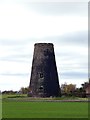
Thomson's windmill
Early 19th century mill at Mowbray Farm
Image: © Graham Hogg
Taken: 28 Nov 2017
0.15 miles
8
The windmill at Mowbray Farm, Epworth
Not as complete as the windmills to the north of the village
Image: © Tim Heaton
Taken: 23 Oct 2015
0.16 miles
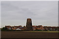
9
Heading towards Epworth & Thompson's Mill on Peatland's Way
Image: © Colin Park
Taken: 13 Aug 2019
0.16 miles
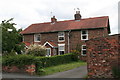
10
Junction of Albion Hill and Mowbray Street
Image: © Glyn Drury
Taken: 1 Apr 2009
0.16 miles