IMAGES TAKEN NEAR TO
Mill View Close, DONCASTER, DN9 1GQ
Introduction
This page details the photographs taken nearby to Mill View Close, DN9 1GQ by members of the Geograph project.
The Geograph project started in 2005 with the aim of publishing, organising and preserving representative images for every square kilometre of Great Britain, Ireland and the Isle of Man.

There are currently over 7.5m images from over14,400 individuals and you can help contribute to the project by visiting https://www.geograph.org.uk
Image Map
Images are licensed for reuse under creativecommons.org/licenses/by-sa/2.0
Notes
- Clicking on the map will re-center to the selected point.
- The higher the marker number, the further away the image location is from the centre of the postcode.
Image Listing (59 Images Found)
Images are licensed for reuse under creativecommons.org/licenses/by-sa/2.0
Image
Details
Distance
1
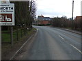
Belton Road (A161) entering Epworth
Heading south.
Image: © JThomas
Taken: 28 Feb 2015
0.04 miles
3
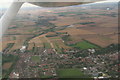
Epworth to Belton: aerial 2014
Disused railway on the left.
Image: © Chris
Taken: 29 Jul 2014
0.05 miles
4
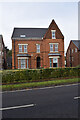
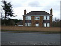
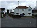
The Gables, Epworth
Offices of the former Isle of Axholme Rural District Council now business units.
Image: © Chris Sayles
Taken: 13 Oct 2024
0.07 miles
6
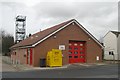
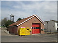
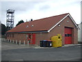
Epworth fire station
Epworth fire station, Tottermire Lane, Epworth, which forms part of Humberside Fire & Rescue Service
Image: © Kevin Hale
Taken: 7 Dec 2009
0.09 miles
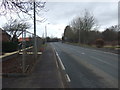
9
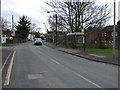
Bus stop and shelter on Belton Road (A161), Epworth
Image: © JThomas
Taken: 28 Feb 2015
0.11 miles