IMAGES TAKEN NEAR TO
Aldam Drive, DONCASTER, DN9 1FG
Introduction
This page details the photographs taken nearby to Aldam Drive, DN9 1FG by members of the Geograph project.
The Geograph project started in 2005 with the aim of publishing, organising and preserving representative images for every square kilometre of Great Britain, Ireland and the Isle of Man.

There are currently over 7.5m images from over14,400 individuals and you can help contribute to the project by visiting https://www.geograph.org.uk
Image Map
Images are licensed for reuse under creativecommons.org/licenses/by-sa/2.0
Notes
- Clicking on the map will re-center to the selected point.
- The higher the marker number, the further away the image location is from the centre of the postcode.
Image Listing (26 Images Found)
Images are licensed for reuse under creativecommons.org/licenses/by-sa/2.0
Image
Details
Distance
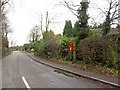
2
Entrance to bridleway on Jeffrey Lane
The bridleway follows the course of the former Axholme Joint Railway. This opened in 1905, closed to passengers in 1933 and to all traffic in 1965.
Image: © Jonathan Thacker
Taken: 27 Jul 2010
0.10 miles


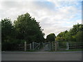
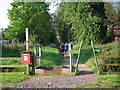
6
Belton Pinfold
A former enclosure where stray animals were impounded until claimed.
Image: © JThomas
Taken: 23 Nov 2013
0.14 miles
7
The disused railway line to the East of Belton
Image: © Ian S
Taken: 21 May 2011
0.16 miles
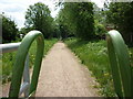
9
Sunday morning run down the course of the old railway in Belton
Image: © Chris
Taken: 18 May 2014
0.16 miles