IMAGES TAKEN NEAR TO
Hollingsworth Lane, DONCASTER, DN9 1EY
Introduction
This page details the photographs taken nearby to Hollingsworth Lane, DN9 1EY by members of the Geograph project.
The Geograph project started in 2005 with the aim of publishing, organising and preserving representative images for every square kilometre of Great Britain, Ireland and the Isle of Man.

There are currently over 7.5m images from over14,400 individuals and you can help contribute to the project by visiting https://www.geograph.org.uk
Image Map
Images are licensed for reuse under creativecommons.org/licenses/by-sa/2.0
Notes
- Clicking on the map will re-center to the selected point.
- The higher the marker number, the further away the image location is from the centre of the postcode.
Image Listing (127 Images Found)
Images are licensed for reuse under creativecommons.org/licenses/by-sa/2.0
Image
Details
Distance
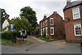
1
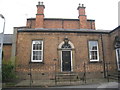
The Old Courthouse, Epworth
Dates from 1848.
Image: © Jonathan Thacker
Taken: 30 Oct 2012
0.06 miles
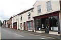
2
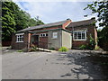
Former school, Epworth
Latterly used as the church hall.
Image: © Jonathan Thacker
Taken: 8 Jul 2014
0.10 miles
3
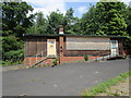
Former school building, Epworth
Now awaiting sale and redevelopment.
Image: © Jonathan Thacker
Taken: 8 Jul 2014
0.11 miles
4
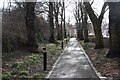
Church Walk
Descent from St.Andrew's church
Image: © Richard Croft
Taken: 10 Feb 2009
0.12 miles
5
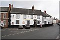
The Red Lion
18th century inn on the east side of Epworth marketplace
Image: © Richard Croft
Taken: 10 Feb 2009
0.12 miles
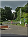
9
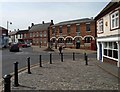
Market Place Epworth
In the centre are the steps where John Wesley preached many times.
Image: © Steve Fareham
Taken: 3 May 2008
0.14 miles
10

Church Walk
Tree lined approach to St.Andrew's church with the promise of a daffodil display in a few weeks time
Image: © Richard Croft
Taken: 10 Feb 2009
0.14 miles