IMAGES TAKEN NEAR TO
Low Burnham, Epworth, DONCASTER, DN9 1DB
Introduction
This page details the photographs taken nearby to DN9 1DB by members of the Geograph project.
The Geograph project started in 2005 with the aim of publishing, organising and preserving representative images for every square kilometre of Great Britain, Ireland and the Isle of Man.

There are currently over 7.5m images from over14,400 individuals and you can help contribute to the project by visiting https://www.geograph.org.uk
Image Map
Images are licensed for reuse under creativecommons.org/licenses/by-sa/2.0
Notes
- Clicking on the map will re-center to the selected point.
- The higher the marker number, the further away the image location is from the centre of the postcode.
Image Listing (19 Images Found)
Images are licensed for reuse under creativecommons.org/licenses/by-sa/2.0
Image
Details
Distance
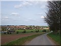
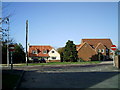
1
Low Burnham village
Small hamlet of Low Burnham as seen from A161
Image: © ghandi
Taken: 12 Nov 2005
0.02 miles
3
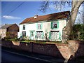
Spondon House
Large detached property in Low Burnham
Image: © Graham Hogg
Taken: 28 Nov 2017
0.05 miles
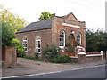
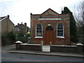
5
Burnham Methodist Chapel
Dating from 1872 the building is now the Low Burnham Village Centre
Image: © Graham Hogg
Taken: 28 Nov 2017
0.08 miles
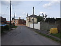
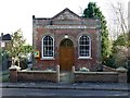
6
Burnham Methodist Chapel
On Epworth Road (A161).
Image: © JThomas
Taken: 28 Feb 2015
0.09 miles
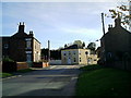
8
Road junction into Low Burnham village
Junction into village from A161
Image: © ghandi
Taken: 12 Nov 2005
0.12 miles
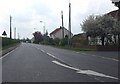
9
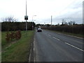
Epworth Road (A161), Low Burnham
Heading north east.
Image: © JThomas
Taken: 28 Feb 2015
0.14 miles