IMAGES TAKEN NEAR TO
Somerby Drive, DONCASTER, DN9 1BS
Introduction
This page details the photographs taken nearby to Somerby Drive, DN9 1BS by members of the Geograph project.
The Geograph project started in 2005 with the aim of publishing, organising and preserving representative images for every square kilometre of Great Britain, Ireland and the Isle of Man.

There are currently over 7.5m images from over14,400 individuals and you can help contribute to the project by visiting https://www.geograph.org.uk
Image Map
Images are licensed for reuse under creativecommons.org/licenses/by-sa/2.0
Notes
- Clicking on the map will re-center to the selected point.
- The higher the marker number, the further away the image location is from the centre of the postcode.
Image Listing (60 Images Found)
Images are licensed for reuse under creativecommons.org/licenses/by-sa/2.0
Image
Details
Distance


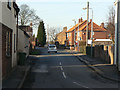
5
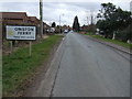
Entering Owston Ferry
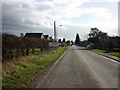
Heading south on Epworth Road.
Image: © JThomas
Taken: 28 Feb 2015
0.11 miles

7

Owston Ferry: aerial
This is a picture of the village centre.
Kinnaird Castle and St.Martin's church are featured in Image; Image
Image: © Chris
Taken: 2 Sep 2012
0.14 miles
8
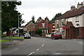
Owston Ferry: Church Street and the turn-off to Epworth
Image: © Chris
Taken: 4 Aug 2013
0.15 miles
9
Epworth Road, Owston Ferry
Looking north from High Street.
Image: © Alan Murray-Rust
Taken: 13 Mar 2011
0.15 miles
10
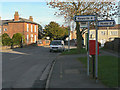
Epworth Road postbox ref: DN9 107
EIIR lamp box serving the upper part of the village.
Image: © Alan Murray-Rust
Taken: 13 Mar 2011
0.17 miles