IMAGES TAKEN NEAR TO
Dunstan Walk, DONCASTER, DN8 5UP
Introduction
This page details the photographs taken nearby to Dunstan Walk, DN8 5UP by members of the Geograph project.
The Geograph project started in 2005 with the aim of publishing, organising and preserving representative images for every square kilometre of Great Britain, Ireland and the Isle of Man.

There are currently over 7.5m images from over14,400 individuals and you can help contribute to the project by visiting https://www.geograph.org.uk
Image Map
Images are licensed for reuse under creativecommons.org/licenses/by-sa/2.0
Notes
- Clicking on the map will re-center to the selected point.
- The higher the marker number, the further away the image location is from the centre of the postcode.
Image Listing (123 Images Found)
Images are licensed for reuse under creativecommons.org/licenses/by-sa/2.0
Image
Details
Distance

2
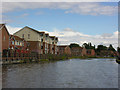
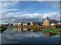
Thorne Waterside
This modern housing on the north side of the canal at Thorne occupies the former site of the Richard Dunston shipyard which closed in the early 1980's after around a century in this location.
Image: © George Robinson
Taken: 12 Aug 2007
0.05 miles
4
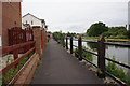
Drainage area, Dunstan Drive, Thorne
On the north bank of the Stainforth & Keadby Canal.
Image: © Christine Johnstone
Taken: 30 Sep 2016
0.05 miles
5
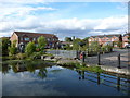
Former dry dock. Dunston Drive, Thorne
Dunston is a well known name in shipbuilding and repair.
Image: © Ian S
Taken: 6 Jun 2018
0.05 miles
6

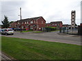
Thorne fire station
Thorne fire station, Union Road, Thorne, Doncaster, South Yorkshire
Image: © Kevin Hale
Taken: 5 Jun 2009
0.06 miles
7
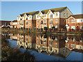
Canalside housing, Thorne
On Orchard Street and Dunstan Drive. On the north bank of the Stainforth & Keadby Canal.
Image: © Christine Johnstone
Taken: 30 Sep 2016
0.06 miles
8
Flats by the canal, Thorne
Housing at Dunstan Drive, seen from the south bank of the Stainforth and Keadby Canal
Image: © Paul Harrop
Taken: 29 Dec 2015
0.06 miles
10
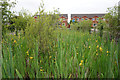
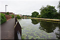
Thorne (Old) railway station (site), Yorkshire
Opened in 1859 on the South Yorkshire Railway's extension from Doncaster via Thorne Lock to Keadby, this station on Orchard Street replaced the short-lived one at Thorn Lock. In turn, it closed in 1866 when it was replaced by Thorne South station on a much straighter railway alignment.
View west towards Thorn Lock. From old maps, the station site is probably somewhere near the modern houses. No trace of a railway at this location now exists.
Image: © Nigel Thompson
Taken: 30 Jul 2019
0.08 miles