IMAGES TAKEN NEAR TO
Gibbon Lane, DONCASTER, DN8 5TY
Introduction
This page details the photographs taken nearby to Gibbon Lane, DN8 5TY by members of the Geograph project.
The Geograph project started in 2005 with the aim of publishing, organising and preserving representative images for every square kilometre of Great Britain, Ireland and the Isle of Man.

There are currently over 7.5m images from over14,400 individuals and you can help contribute to the project by visiting https://www.geograph.org.uk
Image Map
Images are licensed for reuse under creativecommons.org/licenses/by-sa/2.0
Notes
- Clicking on the map will re-center to the selected point.
- The higher the marker number, the further away the image location is from the centre of the postcode.
Image Listing (6 Images Found)
Images are licensed for reuse under creativecommons.org/licenses/by-sa/2.0
Image
Details
Distance
2
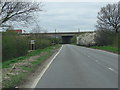
Kirton Lane, passing under the M18 motorway
Image: © Bill Henderson
Taken: 10 Apr 2007
0.23 miles
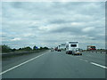
4
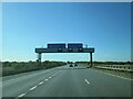
Get in lane motorway split M18 and M180
Left hand lane for the start of the M180 to Grimsby outside lanes M18 for M1. Approaching Junction 5 southbound
Image: © Martin Dawes
Taken: 19 May 2021
0.25 miles