IMAGES TAKEN NEAR TO
Thorne Road, DONCASTER, DN8 5TB
Introduction
This page details the photographs taken nearby to Thorne Road, DN8 5TB by members of the Geograph project.
The Geograph project started in 2005 with the aim of publishing, organising and preserving representative images for every square kilometre of Great Britain, Ireland and the Isle of Man.

There are currently over 7.5m images from over14,400 individuals and you can help contribute to the project by visiting https://www.geograph.org.uk
Image Map
Images are licensed for reuse under creativecommons.org/licenses/by-sa/2.0
Notes
- Clicking on the map will re-center to the selected point.
- The higher the marker number, the further away the image location is from the centre of the postcode.
Image Listing (17 Images Found)
Images are licensed for reuse under creativecommons.org/licenses/by-sa/2.0
Image
Details
Distance
2
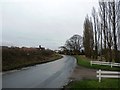
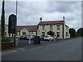
Sandtoft Village
Heading into the village from the west.
Image: © Jonathan Clitheroe
Taken: 20 Feb 2016
0.05 miles

4
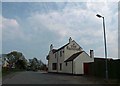
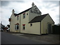
A long way from Lapland!
The Reindeer Public House Sandtoft.
Image: © Steve Fareham
Taken: 5 May 2008
0.07 miles
8
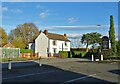
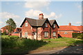
White house in Sandtoft
Photograph taken from the car park of "The Reindeer Inn".
Image: © Neil Theasby
Taken: 12 Nov 2020
0.10 miles
10
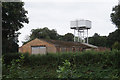
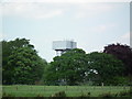
Water Tower at Sandtoft
Taken from Idle Bank.
Image: © Ian S
Taken: 29 Aug 2020
0.14 miles