IMAGES TAKEN NEAR TO
Southfield Road, DONCASTER, DN8 5NU
Introduction
This page details the photographs taken nearby to Southfield Road, DN8 5NU by members of the Geograph project.
The Geograph project started in 2005 with the aim of publishing, organising and preserving representative images for every square kilometre of Great Britain, Ireland and the Isle of Man.

There are currently over 7.5m images from over14,400 individuals and you can help contribute to the project by visiting https://www.geograph.org.uk
Image Map
Images are licensed for reuse under creativecommons.org/licenses/by-sa/2.0
Notes
- Clicking on the map will re-center to the selected point.
- The higher the marker number, the further away the image location is from the centre of the postcode.
Image Listing (19 Images Found)
Images are licensed for reuse under creativecommons.org/licenses/by-sa/2.0
Image
Details
Distance
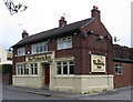
2
Ellison Street, Thorne
Park Crescent is on the right, Milton Court on the left.
Image: © John Lucas
Taken: 21 Jan 2020
0.10 miles
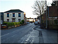
4
Walking through Thorne on Southend Road
Needed to negotiate a police car parked on the pavement - doesn't look as though it was an emergency!
Image: © John Lucas
Taken: 21 Jan 2020
0.17 miles
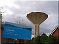
5
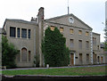
Thorne - Social Services offices
Now derelict.
Image: © Dave Bevis
Taken: 29 Apr 2011
0.18 miles
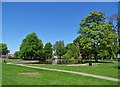
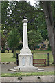
6
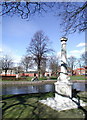
Thorne Park
Looking northwest across the duck pond in Thorne Park from the war memorial, which was refurbished and re-dedicated on 30 September 2004 in a ceremony attended by HRH The Duke of Kent.
Image: © Paul Glazzard
Taken: 25 Mar 2008
0.21 miles