IMAGES TAKEN NEAR TO
Houps Road, DONCASTER, DN8 5JD
Introduction
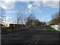
This page details the photographs taken nearby to Houps Road, DN8 5JD by members of the Geograph project.
The Geograph project started in 2005 with the aim of publishing, organising and preserving representative images for every square kilometre of Great Britain, Ireland and the Isle of Man.

There are currently over 7.5m images from over14,400 individuals and you can help contribute to the project by visiting https://www.geograph.org.uk
Image Map
Images are licensed for reuse under creativecommons.org/licenses/by-sa/2.0
Notes
- Clicking on the map will re-center to the selected point.
- The higher the marker number, the further away the image location is from the centre of the postcode.
Image Listing (9 Images Found)
Images are licensed for reuse under creativecommons.org/licenses/by-sa/2.0
Image
Details
Distance
7
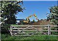
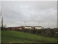
Digger at work on Coulman Road Industrial Estate
Image: © Neil Theasby
Taken: 6 May 2020
0.22 miles
8
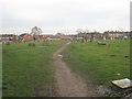
St. Nicholas' churchyard extension
A rather desolate space which could be made much more attractive by the planting of trees and provision of proper footpaths.
Image: © Jonathan Thacker
Taken: 17 Jan 2012
0.24 miles
9
Coulman Street, Thorne
Pavilion for Moorends Hornets and Stingers jfc.
Image: © David Brown
Taken: 2 Mar 2020
0.24 miles