IMAGES TAKEN NEAR TO
Haynes Gardens, DONCASTER, DN8 5HW
Introduction
This page details the photographs taken nearby to Haynes Gardens, DN8 5HW by members of the Geograph project.
The Geograph project started in 2005 with the aim of publishing, organising and preserving representative images for every square kilometre of Great Britain, Ireland and the Isle of Man.

There are currently over 7.5m images from over14,400 individuals and you can help contribute to the project by visiting https://www.geograph.org.uk
Image Map
Images are licensed for reuse under creativecommons.org/licenses/by-sa/2.0
Notes
- Clicking on the map will re-center to the selected point.
- The higher the marker number, the further away the image location is from the centre of the postcode.
Image Listing (12 Images Found)
Images are licensed for reuse under creativecommons.org/licenses/by-sa/2.0
Image
Details
Distance
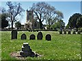
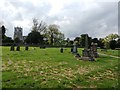
2
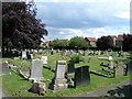
Graveyard Thorne
This is the graveyard for St Nicholas's Church in Thorne
Image: © Michael Patterson
Taken: 3 Feb 2006
0.17 miles
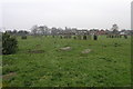
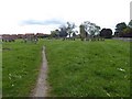
3
St. Nicholas' churchyard extension
A rather desolate space which could be made much more attractive by the planting of trees and provision of proper footpaths.
Image: © Jonathan Thacker
Taken: 17 Jan 2012
0.21 miles
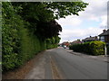
5
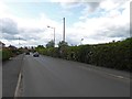
Approaching St Nicholas's Parish Church, Thorne
Image: © Neil Theasby
Taken: 6 May 2020
0.23 miles
6
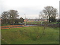
View from Peel Hill
Looking over St. Nicholas' churchyard and extension.
Image: © Jonathan Thacker
Taken: 17 Jan 2012
0.23 miles
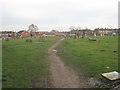
10
Cemetery in Thorne
The Church of St Nicholas (situated to the north west in SK6813) can also be seen here.
Image: © Jonathan Clitheroe
Taken: 23 May 2016
0.24 miles