IMAGES TAKEN NEAR TO
St. Nicholas Road, DONCASTER, DN8 5BG
Introduction
This page details the photographs taken nearby to St. Nicholas Road, DN8 5BG by members of the Geograph project.
The Geograph project started in 2005 with the aim of publishing, organising and preserving representative images for every square kilometre of Great Britain, Ireland and the Isle of Man.

There are currently over 7.5m images from over14,400 individuals and you can help contribute to the project by visiting https://www.geograph.org.uk
Image Map
Images are licensed for reuse under creativecommons.org/licenses/by-sa/2.0
Notes
- Clicking on the map will re-center to the selected point.
- The higher the marker number, the further away the image location is from the centre of the postcode.
Image Listing (90 Images Found)
Images are licensed for reuse under creativecommons.org/licenses/by-sa/2.0
Image
Details
Distance
1
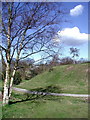
Peel Hill Castle, Thorne
The motte is a Listed National Monument which was purchased for the benefit of the public in 1979 from the proceeds of Thorne Town Lottery. The castle was possibly a hunting lodge for Hatfield Chase. A stone tower stood on the motte until the 16th century and there was probably a bailey to the south.
Image: © Paul Glazzard
Taken: 25 Mar 2008
0.04 miles
2
Peel Hill Motte
Site of a Norman Castle in the middle of Thorne
Image: © Martin Dawes
Taken: 29 Feb 2012
0.05 miles
3

Peel Hill from the south-east
A Norman motte and bailey.
Image: © Jonathan Thacker
Taken: 17 Jan 2012
0.06 miles
4

Peel Hill
A Norman motte and bailey.
Image: © Jonathan Thacker
Taken: 17 Jan 2012
0.06 miles
5
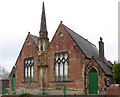
Thorne - Travis's Charity School
For a closer view of the turret, please see Image
Image: © Dave Bevis
Taken: 29 Apr 2011
0.08 miles
7
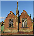
Travis's Charity School, Thorne
Former school building on Church Street, dating from 1863
Image: © Paul Harrop
Taken: 29 Dec 2015
0.08 miles
8
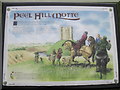
Peel Hill Information Board
Motte french for mound,the Norman's built this when the area was first given by William after 1066 to his barons, it later became a royal hunting area.
Image: © Martin Dawes
Taken: 29 Feb 2012
0.08 miles
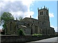
9
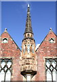
Travis's Charity School, Thorne
Close up of the pinnacle on the front of Travis's Charity School on the north side of Church Street. According to inscriptions on the front, the school was founded in 1770 and the building erected in 1863.
Image: © Paul Glazzard
Taken: 25 Mar 2008
0.09 miles
10
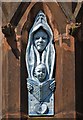
Frontage detail: Travis's Charity School, Thorne
The stunning sculptural relief was created by Byron Howard in modern times - not when the former charity school opened in 1863.
Image: © Neil Theasby
Taken: 6 May 2020
0.09 miles