IMAGES TAKEN NEAR TO
Foundry Lane, DONCASTER, DN8 5AJ
Introduction
This page details the photographs taken nearby to Foundry Lane, DN8 5AJ by members of the Geograph project.
The Geograph project started in 2005 with the aim of publishing, organising and preserving representative images for every square kilometre of Great Britain, Ireland and the Isle of Man.

There are currently over 7.5m images from over14,400 individuals and you can help contribute to the project by visiting https://www.geograph.org.uk
Image Map
Images are licensed for reuse under creativecommons.org/licenses/by-sa/2.0
Notes
- Clicking on the map will re-center to the selected point.
- The higher the marker number, the further away the image location is from the centre of the postcode.
Image Listing (79 Images Found)
Images are licensed for reuse under creativecommons.org/licenses/by-sa/2.0
Image
Details
Distance
1
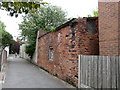
Foundry Lane
This is an old lane once having terraced houses on the left hand side now used as a short cut to main street ... lovely old part of thorne.
Image: © JENNY BRACK
Taken: 18 Jun 2009
0.02 miles
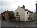
3
Field Side, Thorne
Houses on the north side of the A614 as it leads west, away from the town centre
Image: © Paul Harrop
Taken: 29 Dec 2015
0.03 miles
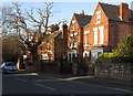
4

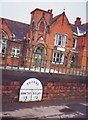
The former Carnegie Free Library
Of a piece with the Police Station and Courts across the road Image
Image: © Jonathan Thacker
Taken: 27 Jan 2012
0.04 miles
5
Carnegie Free Library
Long-disused and boarded up, the former Carnegie Library has probably escaped the worst attentions of vandals by being directly opposite the Police Station. Now sold and awaiting a new lease of life.
Image: © Richard Croft
Taken: 8 Mar 2010
0.05 miles
6
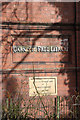
Foundation stone
Foundation stone in the former Carnegie Free Library http://www.geograph.org.uk/photo/1743480
This Stone was laid by
James Servant
Dec 14 1903
Image: © Richard Croft
Taken: 8 Mar 2010
0.05 miles
7
Old Milepost by the A614, Fieldside, Thorne
Milepost by the A614, in parish of Thorne (Doncaster District), Field Side, fixed to wall North of Browns Lane opposite, by the road.
Inscription reads:-
: BAWTRY / 14 : : THORNE : : SELBY / 15 :
Lost since 1990. Was Grade II listed.
Milestone Society National ID: YS_BWTH14
Image: © Milestone Society
Taken: Unknown
0.05 miles
8
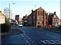
Approaching Thorne town centre
In King Street.
Image: © John Lucas
Taken: 21 Jan 2020
0.06 miles
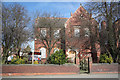
9
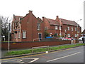
Police Station and Court
Of a piece with the Carnegie Free Library across the road Image
Image: © Jonathan Thacker
Taken: 27 Jan 2012
0.07 miles
10
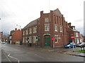
Thorne-Moorends Town Council
Built as the Temperance Institute in 1909.
Image: © Jonathan Thacker
Taken: 27 Jan 2012
0.07 miles