IMAGES TAKEN NEAR TO
Marshland Road, DONCASTER, DN8 4RS
Introduction
This page details the photographs taken nearby to Marshland Road, DN8 4RS by members of the Geograph project.
The Geograph project started in 2005 with the aim of publishing, organising and preserving representative images for every square kilometre of Great Britain, Ireland and the Isle of Man.

There are currently over 7.5m images from over14,400 individuals and you can help contribute to the project by visiting https://www.geograph.org.uk
Image Map
Images are licensed for reuse under creativecommons.org/licenses/by-sa/2.0
Notes
- Clicking on the map will re-center to the selected point.
- The higher the marker number, the further away the image location is from the centre of the postcode.
Image Listing (14 Images Found)
Images are licensed for reuse under creativecommons.org/licenses/by-sa/2.0
Image
Details
Distance
1
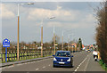
Marshland Road, Moorends
The main road between Thorne and Moorends.
Image: © Martin Loader
Taken: 14 Mar 2007
0.01 miles
2
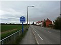
Moorends Welcome Sign
Entrance sign situated on Marshland Road.
Image: © Jonathan Clitheroe
Taken: 18 Apr 2016
0.01 miles


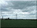

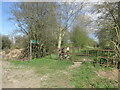
7
Track near Broadgate Farm
Provides access to the footpath leading to the Humberhead Peatlands National Nature Reserve.
Image: © Jonathan Thacker
Taken: 25 Nov 2011
0.13 miles
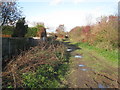
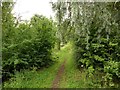
8
Footpath to Thorne Moors
On the edge of Moorends.
Image: © steven ruffles
Taken: 29 Mar 2021
0.16 miles
9

Junction of Coulman Road and King Edward Road
Image: © Glyn Drury
Taken: 4 Apr 2009
0.16 miles
10
Footpath to Thorne Waste
The footpath is known as Jones Cable Access and runs between Moorends and the Humberlands Peatlands National Nature Reserve on Thorne Waste http://www.humberheadpeatlands.org.uk/
Image: © Graham Hogg
Taken: 25 Jul 2017
0.17 miles