IMAGES TAKEN NEAR TO
Park Road, DONCASTER, DN8 4QG
Introduction
This page details the photographs taken nearby to Park Road, DN8 4QG by members of the Geograph project.
The Geograph project started in 2005 with the aim of publishing, organising and preserving representative images for every square kilometre of Great Britain, Ireland and the Isle of Man.

There are currently over 7.5m images from over14,400 individuals and you can help contribute to the project by visiting https://www.geograph.org.uk
Image Map
Images are licensed for reuse under creativecommons.org/licenses/by-sa/2.0
Notes
- Clicking on the map will re-center to the selected point.
- The higher the marker number, the further away the image location is from the centre of the postcode.
Image Listing (27 Images Found)
Images are licensed for reuse under creativecommons.org/licenses/by-sa/2.0
Image
Details
Distance
5
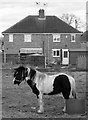
Forlorn pony on wasteland at Moorends (II)
Near the junction of Grange Road and Northgate, Moorends.
Image: © Neil Theasby
Taken: 18 Feb 2017
0.17 miles
6
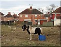
Forlorn pony on wasteland at Moorends (I)
Near the corner of Grange Road and Northgate
Image: © Neil Theasby
Taken: 18 Feb 2017
0.17 miles
7
Forlorn pony on wasteland at Moorends (III)
Near the junction of Northgate and Grange Road
Image: © Neil Theasby
Taken: 18 Feb 2017
0.18 miles
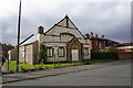
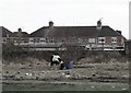
9
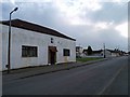
St. John's Ambulance Brigade Moorends HQ
On Grange Road, the post in the centre is a CCTV camera.
Image: © Steve Fareham
Taken: 24 Mar 2008
0.18 miles
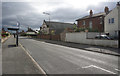
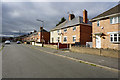
10
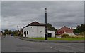
Grange Road/North Gate junction, Moorends
Image: © Neil Theasby
Taken: 30 Sep 2012
0.19 miles