IMAGES TAKEN NEAR TO
Goole Road, DONCASTER, DN8 4JX
Introduction
This page details the photographs taken nearby to Goole Road, DN8 4JX by members of the Geograph project.
The Geograph project started in 2005 with the aim of publishing, organising and preserving representative images for every square kilometre of Great Britain, Ireland and the Isle of Man.

There are currently over 7.5m images from over14,400 individuals and you can help contribute to the project by visiting https://www.geograph.org.uk
Image Map
Images are licensed for reuse under creativecommons.org/licenses/by-sa/2.0
Notes
- Clicking on the map will re-center to the selected point.
- The higher the marker number, the further away the image location is from the centre of the postcode.
Image Listing (12 Images Found)
Images are licensed for reuse under creativecommons.org/licenses/by-sa/2.0
Image
Details
Distance
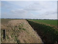
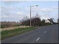
2
Crown Farm and Moorends Road
Situated at the north eastern corner of the grid square.
Image: © Jonathan Clitheroe
Taken: 18 Apr 2016
0.11 miles
5
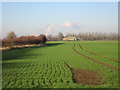
Moorends Farm
Seen from near Warp Farm.
Image: © Jonathan Thacker
Taken: 25 Jan 2017
0.13 miles
6
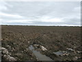
Ploughed Field near Moorends Farm
Image: © Jonathan Clitheroe
Taken: 18 Apr 2016
0.15 miles
7
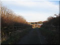
View from the bridge over the motorway
Looking towards Johnny Moor Long Road.
Image: © Jonathan Thacker
Taken: 25 Nov 2012
0.15 miles
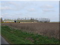
9
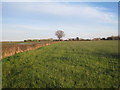
View towards Crown Farm
It doesn't show in this picture but most of this grass field was under water.
Image: © Jonathan Thacker
Taken: 25 Nov 2012
0.18 miles