IMAGES TAKEN NEAR TO
Lime Tree Grove, DONCASTER, DN8 4DH
Introduction
This page details the photographs taken nearby to Lime Tree Grove, DN8 4DH by members of the Geograph project.
The Geograph project started in 2005 with the aim of publishing, organising and preserving representative images for every square kilometre of Great Britain, Ireland and the Isle of Man.

There are currently over 7.5m images from over14,400 individuals and you can help contribute to the project by visiting https://www.geograph.org.uk
Image Map
Images are licensed for reuse under creativecommons.org/licenses/by-sa/2.0
Notes
- Clicking on the map will re-center to the selected point.
- The higher the marker number, the further away the image location is from the centre of the postcode.
Image Listing (20 Images Found)
Images are licensed for reuse under creativecommons.org/licenses/by-sa/2.0
Image
Details
Distance
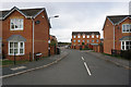
2
Peatends Way towards North Eastern Road, Thorne
Image: © Ian S
Taken: 3 Oct 2018
0.15 miles
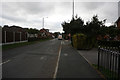
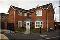
5

King Edward Road in Thorne
Looking in the direction of Moorends.
Image: © Jonathan Clitheroe
Taken: 18 Apr 2016
0.19 miles
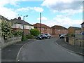
6
North Eastern Road at Mill Croft Close, Thorne
Image: © Ian S
Taken: 3 Oct 2018
0.19 miles
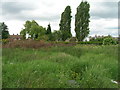
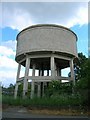
9

Water Tower at Thorne
Seen from Sainsbury's carpark. There is another water tower of the inverted pyramid type on the southern edge of the town.
Image: © Jonathan Thacker
Taken: 10 Dec 2011
0.21 miles