IMAGES TAKEN NEAR TO
Pudding & Dip Lane, DONCASTER, DN7 6TP
Introduction
This page details the photographs taken nearby to Pudding & Dip Lane, DN7 6TP by members of the Geograph project.
The Geograph project started in 2005 with the aim of publishing, organising and preserving representative images for every square kilometre of Great Britain, Ireland and the Isle of Man.

There are currently over 7.5m images from over14,400 individuals and you can help contribute to the project by visiting https://www.geograph.org.uk
Image Map
Images are licensed for reuse under creativecommons.org/licenses/by-sa/2.0
Notes
- Clicking on the map will re-center to the selected point.
- The higher the marker number, the further away the image location is from the centre of the postcode.
Image Listing (4 Images Found)
Images are licensed for reuse under creativecommons.org/licenses/by-sa/2.0
Image
Details
Distance
1
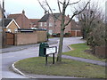
Pudding and Dip Lane
I have been unable to find any explanation for this strange name, which goes back some way, as it appears on the 1850s OS maps.
Image: © Alan Murray-Rust
Taken: 8 Feb 2010
0.04 miles
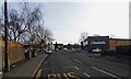
3
Station Road, Hatfield
Where I am standing would originally have been in the hamlet of Dunscroft, a name which is now applied to the housing development to the south west of Hatfield village. Housing is continuous so it is difficult to know where the boundary really lies.
Image: © Alan Murray-Rust
Taken: 8 Feb 2010
0.13 miles