IMAGES TAKEN NEAR TO
Station Road, DONCASTER, DN7 6QJ
Introduction
This page details the photographs taken nearby to Station Road, DN7 6QJ by members of the Geograph project.
The Geograph project started in 2005 with the aim of publishing, organising and preserving representative images for every square kilometre of Great Britain, Ireland and the Isle of Man.

There are currently over 7.5m images from over14,400 individuals and you can help contribute to the project by visiting https://www.geograph.org.uk
Image Map
Images are licensed for reuse under creativecommons.org/licenses/by-sa/2.0
Notes
- Clicking on the map will re-center to the selected point.
- The higher the marker number, the further away the image location is from the centre of the postcode.
Image Listing (19 Images Found)
Images are licensed for reuse under creativecommons.org/licenses/by-sa/2.0
Image
Details
Distance
1
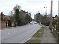
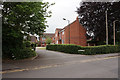
Station Road, Hatfield
Where I am standing would originally have been in the hamlet of Dunscroft, a name which is now applied to the housing development to the south west of Hatfield village. Housing is continuous so it is difficult to know where the boundary really lies.
Image: © Alan Murray-Rust
Taken: 8 Feb 2010
0.06 miles
2
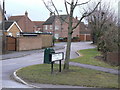
Pudding and Dip Lane
I have been unable to find any explanation for this strange name, which goes back some way, as it appears on the 1850s OS maps.
Image: © Alan Murray-Rust
Taken: 8 Feb 2010
0.15 miles
3
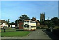
Hatfield bus turnround ? 1978
Compare with the same location in 2010 https://www.geograph.org.uk/photo/1709151 .
The bus is South Yorkshire PTE 1209, formerly Doncaster Corporation 209, a Daimler Fleetline new in 1967, operating on the service from Doncaster to Dunscroft which the PTE, as successor to Doncaster Corporation, shared with a number of small independent operators.
This is one of a series of views featuring buses in the 60s, 70s, and 80s. http://www.geograph.org.uk/search.php?i=137652761
Image: © Alan Murray-Rust
Taken: 14 Sep 1978
0.18 miles
4

Hatfield bus terminus
The long-standing terminus of buses from Doncaster at Westfield Villas. Up until the early 70s this route was provided by a variety of local operators with a colourful selection of buses.
Image: © Alan Murray-Rust
Taken: 8 Feb 2010
0.19 miles
5
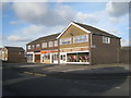
All you need for an evening in
These shops sell T.V.s, takeaways and comfy chairs. Sorted!
Image: © Jonathan Thacker
Taken: 30 Dec 2012
0.20 miles

8
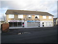
Cakes, tans and blow-dries
Shops on Ash Hill Crescent.
Image: © Jonathan Thacker
Taken: 30 Dec 2012
0.22 miles
9
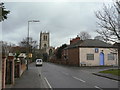
Station Road, Hatfield
The church with its perpendicular exterior stands impressively above the older part of the village.
Image: © Alan Murray-Rust
Taken: 8 Feb 2010
0.22 miles
10
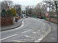
Cuckoo Lane
An old established field lane leading out of the village to the north; it becomes a bridleway at the end of the built up part of the village.
Image: © Alan Murray-Rust
Taken: 8 Feb 2010
0.23 miles