IMAGES TAKEN NEAR TO
Albany Drive, DN7 6FG
Introduction
This page details the photographs taken nearby to Albany Drive, DN7 6FG by members of the Geograph project.
The Geograph project started in 2005 with the aim of publishing, organising and preserving representative images for every square kilometre of Great Britain, Ireland and the Isle of Man.

There are currently over 7.5m images from over14,400 individuals and you can help contribute to the project by visiting https://www.geograph.org.uk
Image Map
Images are licensed for reuse under creativecommons.org/licenses/by-sa/2.0
Notes
- Clicking on the map will re-center to the selected point.
- The higher the marker number, the further away the image location is from the centre of the postcode.
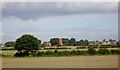
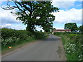
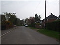
Image Listing (11 Images Found)
Images are licensed for reuse under creativecommons.org/licenses/by-sa/2.0
Image
Details
Distance
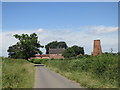
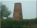
2
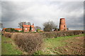
Lings Windmill
On Lings Lane, south of Dunscroft
Image: © Richard Croft
Taken: 3 Apr 2006
0.14 miles
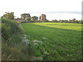
3
Lings windmill.
Lings lane south of Hatfield.
Image: © steven ruffles
Taken: 18 Jun 2018
0.15 miles
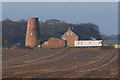
4
Lings Windmill
Converted to housing.
Image: © Jonathan Thacker
Taken: 6 Aug 2012
0.15 miles
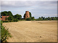
8
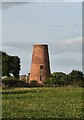
Lings Windmill, Hatfield, Doncaster
Lings Windmill is a 19th century tower mill on the edge of Hatfield village. It has three floors.
It was listed by English Heritage in 1987 at Grade II.
Image: © Colin Cheesman
Taken: 10 Oct 2021
0.17 miles