IMAGES TAKEN NEAR TO
Hollin Bridge Road, DONCASTER, DN7 6DX
Introduction
This page details the photographs taken nearby to Hollin Bridge Road, DN7 6DX by members of the Geograph project.
The Geograph project started in 2005 with the aim of publishing, organising and preserving representative images for every square kilometre of Great Britain, Ireland and the Isle of Man.

There are currently over 7.5m images from over14,400 individuals and you can help contribute to the project by visiting https://www.geograph.org.uk
Image Map
Images are licensed for reuse under creativecommons.org/licenses/by-sa/2.0
Notes
- Clicking on the map will re-center to the selected point.
- The higher the marker number, the further away the image location is from the centre of the postcode.
Image Listing (14 Images Found)
Images are licensed for reuse under creativecommons.org/licenses/by-sa/2.0
Image
Details
Distance

3
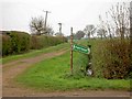
Footpath sign near Hatfield Woodhouse
Complete with a robin perched on the pole.
Image: © Steve Fareham
Taken: 11 Apr 2009
0.03 miles
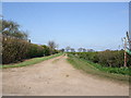
8
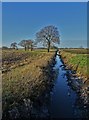
West Moor Drain south of Hatfield Woodhouse
Image: © Neil Theasby
Taken: 19 Jan 2020
0.14 miles
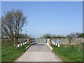
10
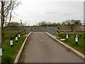
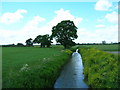
Moor Dike Road crosses Hatfield waste drain
With the sewage works in the background.
Image: © Steve Fareham
Taken: 11 Apr 2009
0.16 miles