IMAGES TAKEN NEAR TO
Cunningham Road, DONCASTER, DN7 6BZ
Introduction
This page details the photographs taken nearby to Cunningham Road, DN7 6BZ by members of the Geograph project.
The Geograph project started in 2005 with the aim of publishing, organising and preserving representative images for every square kilometre of Great Britain, Ireland and the Isle of Man.

There are currently over 7.5m images from over14,400 individuals and you can help contribute to the project by visiting https://www.geograph.org.uk
Image Map
Images are licensed for reuse under creativecommons.org/licenses/by-sa/2.0
Notes
- Clicking on the map will re-center to the selected point.
- The higher the marker number, the further away the image location is from the centre of the postcode.
Image Listing (5 Images Found)
Images are licensed for reuse under creativecommons.org/licenses/by-sa/2.0
Image
Details
Distance
1
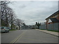
HM Prison Lindholme.
Lindholme is used as an immigration reception centre.
Image: © Bill Henderson
Taken: 10 Apr 2007
0.11 miles
2
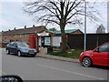
Post Office and Shop , former RAF Station, Lindholme.
This housing estate was once the housing for the families of the men of RAF Lindholme.
Image: © Bill Henderson
Taken: 10 Apr 2007
0.14 miles
4
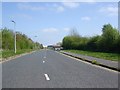
Lancaster Drive approaching HMP Lindholme
Image: © Glyn Drury
Taken: 15 Apr 2009
0.17 miles
5

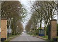
Main Entrance to H.M. Prison, Moorland
Image: © Bill Henderson
Taken: 10 Apr 2007
0.18 miles