IMAGES TAKEN NEAR TO
Lings Lane, DONCASTER, DN7 6AB
Introduction
This page details the photographs taken nearby to Lings Lane, DN7 6AB by members of the Geograph project.
The Geograph project started in 2005 with the aim of publishing, organising and preserving representative images for every square kilometre of Great Britain, Ireland and the Isle of Man.

There are currently over 7.5m images from over14,400 individuals and you can help contribute to the project by visiting https://www.geograph.org.uk
Image Map
Images are licensed for reuse under creativecommons.org/licenses/by-sa/2.0
Notes
- Clicking on the map will re-center to the selected point.
- The higher the marker number, the further away the image location is from the centre of the postcode.
Image Listing (11 Images Found)
Images are licensed for reuse under creativecommons.org/licenses/by-sa/2.0
Image
Details
Distance
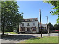
2
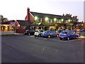
The Hatfield Chase
Pub/restaurant, Doncaster Road, Hatfield.
Image: © David Dixon
Taken: 14 Oct 2011
0.14 miles
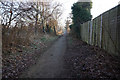
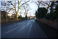
4
Coppice Lane
Starts from Doncaster Road as a metalled road but soon turns to this track.
Image: © Jonathan Thacker
Taken: 30 Dec 2012
0.17 miles
7
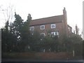
Bow House
Hatfield has a number of substantial houses from the late eighteenth century which must have been a time of some prosperity here. http://www.britishlistedbuildings.co.uk/en-334627-bow-house-hatfield-
Image: © Jonathan Thacker
Taken: 30 Dec 2012
0.23 miles
8
Hatfields public house.
One of many pubs in the Hatfield area.
Image: © steven ruffles
Taken: 18 Jun 2018
0.24 miles
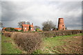
9
Lings Windmill
Converted to housing.
Image: © Jonathan Thacker
Taken: 6 Aug 2012
0.24 miles
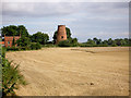
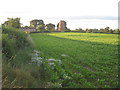
10
Lings Windmill
On Lings Lane, south of Dunscroft
Image: © Richard Croft
Taken: 3 Apr 2006
0.24 miles