IMAGES TAKEN NEAR TO
Bramwith Woodhouse, Stainforth, DONCASTER, DN7 5TG
Introduction
This page details the photographs taken nearby to DN7 5TG by members of the Geograph project.
The Geograph project started in 2005 with the aim of publishing, organising and preserving representative images for every square kilometre of Great Britain, Ireland and the Isle of Man.

There are currently over 7.5m images from over14,400 individuals and you can help contribute to the project by visiting https://www.geograph.org.uk
Image Map
Images are licensed for reuse under creativecommons.org/licenses/by-sa/2.0
Notes
- Clicking on the map will re-center to the selected point.
- The higher the marker number, the further away the image location is from the centre of the postcode.
Image Listing (9 Images Found)
Images are licensed for reuse under creativecommons.org/licenses/by-sa/2.0
Image
Details
Distance
6
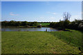
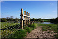
Former route of the River Don
Near Woodhouse Green Farm.
Image: © Ian S
Taken: 10 Apr 2019
0.15 miles
8
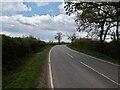
Woodhouse Green Road
The footpath on the map runs parallel to the road but is actually on the far side of a ditch and a hedge so is only accessible near the farm
Image: © David Brown
Taken: 6 May 2021
0.16 miles
9
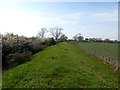
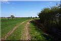
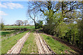
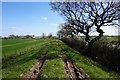
Dyke and Footpath at Woodhouse Green
For a few hundred yards at least, this path runs parallel with Woodhouse Green Road.
Image: © Jonathan Clitheroe
Taken: 9 Apr 2017
0.17 miles