IMAGES TAKEN NEAR TO
Doncaster Road, DONCASTER, DN7 5SF
Introduction
This page details the photographs taken nearby to Doncaster Road, DN7 5SF by members of the Geograph project.
The Geograph project started in 2005 with the aim of publishing, organising and preserving representative images for every square kilometre of Great Britain, Ireland and the Isle of Man.

There are currently over 7.5m images from over14,400 individuals and you can help contribute to the project by visiting https://www.geograph.org.uk
Image Map
Images are licensed for reuse under creativecommons.org/licenses/by-sa/2.0
Notes
- Clicking on the map will re-center to the selected point.
- The higher the marker number, the further away the image location is from the centre of the postcode.
Image Listing (54 Images Found)
Images are licensed for reuse under creativecommons.org/licenses/by-sa/2.0
Image
Details
Distance
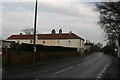
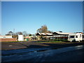
2
Cottages off Doncaster Road, Stainforth
Image: © Jonathan Thacker
Taken: 27 Jan 2012
0.02 miles
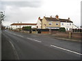
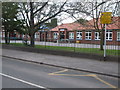
3
Doncaster Road in Stainforth
Looking towards the town centre.
Image: © Jonathan Clitheroe
Taken: 9 Apr 2017
0.04 miles

7
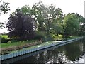
Standing water, south bank, River Dun Navigation
Just west of Stainforth Bridge. Separated from the navigation by sheet piling.
Image: © Christine Johnstone
Taken: 30 Sep 2016
0.10 miles
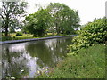
10
Path beside the Stainforth and Keadby Canal heading west
Image: © JThomas
Taken: 26 May 2011
0.12 miles