IMAGES TAKEN NEAR TO
Third Square, DONCASTER, DN7 5RF
Introduction
This page details the photographs taken nearby to Third Square, DN7 5RF by members of the Geograph project.
The Geograph project started in 2005 with the aim of publishing, organising and preserving representative images for every square kilometre of Great Britain, Ireland and the Isle of Man.

There are currently over 7.5m images from over14,400 individuals and you can help contribute to the project by visiting https://www.geograph.org.uk
Image Map
Images are licensed for reuse under creativecommons.org/licenses/by-sa/2.0
Notes
- Clicking on the map will re-center to the selected point.
- The higher the marker number, the further away the image location is from the centre of the postcode.
Image Listing (48 Images Found)
Images are licensed for reuse under creativecommons.org/licenses/by-sa/2.0
Image
Details
Distance
1
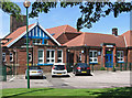
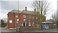
Stainforth - Long Toft Primary School
On Church Road. For an alternative view, please see Image
Image: © Dave Bevis
Taken: 6 Jun 2014
0.07 miles
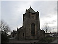
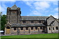
3
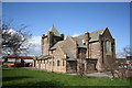
St.Mary's church, Stainforth
On the edge of the pit village of Stainforth
Image: © Richard Croft
Taken: 3 Apr 2006
0.11 miles
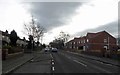
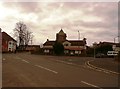
9
The Fox, Field Road, Stainforth
The Fox seems to have gone to ground, another pub unlikely to be trading again.
Image: © Chris Morgan
Taken: 15 Dec 2014
0.14 miles
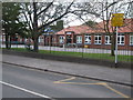
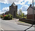
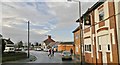
10
Junction of Field Road and Princess Avenue in Stainforth
The Church of St Mary is partially visible here.
Image: © Jonathan Clitheroe
Taken: 5 Dec 2015
0.14 miles