IMAGES TAKEN NEAR TO
West Bank, DONCASTER, DN7 5JG
Introduction
This page details the photographs taken nearby to West Bank, DN7 5JG by members of the Geograph project.
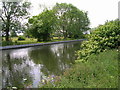
The Geograph project started in 2005 with the aim of publishing, organising and preserving representative images for every square kilometre of Great Britain, Ireland and the Isle of Man.

There are currently over 7.5m images from over14,400 individuals and you can help contribute to the project by visiting https://www.geograph.org.uk
Image Map
Images are licensed for reuse under creativecommons.org/licenses/by-sa/2.0
Notes
- Clicking on the map will re-center to the selected point.
- The higher the marker number, the further away the image location is from the centre of the postcode.
Image Listing (61 Images Found)
Images are licensed for reuse under creativecommons.org/licenses/by-sa/2.0
Image
Details
Distance
1
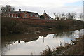
The River Don and flood protection wall at Stainforth
Image: © Graham Hogg
Taken: 15 Dec 2014
0.01 miles
2
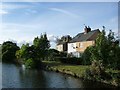
The westernmost houses on West Bank
Their back [south] windows look onto the River Dun Navigation, the front ones onto the River Don.
Image: © Christine Johnstone
Taken: 30 Sep 2016
0.01 miles
3
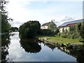
Buildings on West Bank, near Stainforth
Sandwiched between the unseen River Don and the River Dun Navigation.
Image: © Christine Johnstone
Taken: 30 Sep 2016
0.02 miles
4

Path beside the Stainforth and Keadby Canal heading west
Image: © JThomas
Taken: 26 May 2011
0.03 miles
5
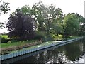
Standing water, south bank, River Dun Navigation
Just west of Stainforth Bridge. Separated from the navigation by sheet piling.
Image: © Christine Johnstone
Taken: 30 Sep 2016
0.04 miles
7
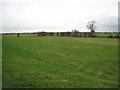
Meadows by the River Don
An almost featureless landscape.
Image: © Jonathan Thacker
Taken: 27 Jan 2012
0.09 miles
9
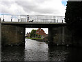
Stainforth Road Bridge
View of the road bridge from the west with the waterside of the village beyond.
Image: © George Robinson
Taken: 12 Aug 2007
0.12 miles
10

The River Dun Navigation
Immediately west of Stainforth Bridge.
Image: © Christine Johnstone
Taken: 30 Sep 2016
0.12 miles