IMAGES TAKEN NEAR TO
Elders Drive, DONCASTER, DN7 5FL
Introduction
This page details the photographs taken nearby to Elders Drive, DN7 5FL by members of the Geograph project.
The Geograph project started in 2005 with the aim of publishing, organising and preserving representative images for every square kilometre of Great Britain, Ireland and the Isle of Man.

There are currently over 7.5m images from over14,400 individuals and you can help contribute to the project by visiting https://www.geograph.org.uk
Image Map
Images are licensed for reuse under creativecommons.org/licenses/by-sa/2.0
Notes
- Clicking on the map will re-center to the selected point.
- The higher the marker number, the further away the image location is from the centre of the postcode.
Image Listing (45 Images Found)
Images are licensed for reuse under creativecommons.org/licenses/by-sa/2.0
Image
Details
Distance
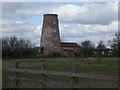
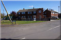
3

Primitive Methodist Baptist Chapel
Dating from 1880
Image: © Graham Hogg
Taken: 15 Dec 2014
0.07 miles
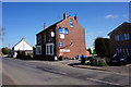
4
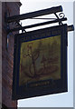
The Old Anchor Inn
On Main Street, Fishlake. https://www.geograph.org.uk/photo/6127885
Image: © Ian S
Taken: 10 Apr 2019
0.07 miles
5
The Old Anchor Inn
On Main Street, Fishlake. https://www.geograph.org.uk/photo/6127891
Image: © Ian S
Taken: 10 Apr 2019
0.07 miles
7

Former Primitive Methodist Chapel
On Trundle Lane, Fishlake.
Image: © Ian S
Taken: 10 Apr 2019
0.09 miles
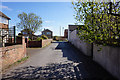
8
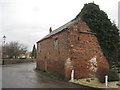
Outhouse on the bend
Lucky to survive given its position on a tight bend in the middle of the village. Maybe the owners are just waiting for the ivy to bring about its collapse.
Image: © Jonathan Thacker
Taken: 27 Jan 2012
0.10 miles