IMAGES TAKEN NEAR TO
York Road, DONCASTER, DN7 4LY
Introduction
This page details the photographs taken nearby to York Road, DN7 4LY by members of the Geograph project.
The Geograph project started in 2005 with the aim of publishing, organising and preserving representative images for every square kilometre of Great Britain, Ireland and the Isle of Man.

There are currently over 7.5m images from over14,400 individuals and you can help contribute to the project by visiting https://www.geograph.org.uk
Image Map
Images are licensed for reuse under creativecommons.org/licenses/by-sa/2.0
Notes
- Clicking on the map will re-center to the selected point.
- The higher the marker number, the further away the image location is from the centre of the postcode.
Image Listing (18 Images Found)
Images are licensed for reuse under creativecommons.org/licenses/by-sa/2.0
Image
Details
Distance
2
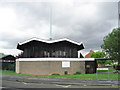
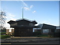
Parish Church of St Edwin
Parish Church of St Edwin, Sheep Dip Lane, Dunscroft.
Image: © Oxana Maher
Taken: 8 May 2007
0.15 miles
5
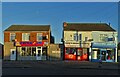
Businesses on Broadway, Dunscroft
A pizza takeaway, a barber's and a fish and chip shop or "chippy" with the moon above - top left of centre.
Image: © Neil Theasby
Taken: 13 Jan 2022
0.16 miles
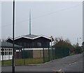
6
St. Edwin's church, Dunscroft
Many churches of this period are beginning to show their age but this looks to be well maintained.
Image: © Jonathan Thacker
Taken: 30 Dec 2012
0.17 miles