IMAGES TAKEN NEAR TO
Eco Way, DONCASTER, DN7 4JJ
Introduction
This page details the photographs taken nearby to Eco Way, DN7 4JJ by members of the Geograph project.
The Geograph project started in 2005 with the aim of publishing, organising and preserving representative images for every square kilometre of Great Britain, Ireland and the Isle of Man.

There are currently over 7.5m images from over14,400 individuals and you can help contribute to the project by visiting https://www.geograph.org.uk
Image Map
Images are licensed for reuse under creativecommons.org/licenses/by-sa/2.0
Notes
- Clicking on the map will re-center to the selected point.
- The higher the marker number, the further away the image location is from the centre of the postcode.
Image Listing (4 Images Found)
Images are licensed for reuse under creativecommons.org/licenses/by-sa/2.0
Image
Details
Distance
2
View towards Hatfield Main colliery
The raised land that is clearly not a slag heap is Bootham Lane landfill site.
Image: © Jonathan Thacker
Taken: 6 Dec 2014
0.22 miles
3
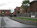
Orchard Grove
Residential area off Station Road.
Image: © Oxana Maher
Taken: 8 May 2007
0.23 miles
4
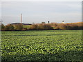
Pudding Lane
Bootham Lane landfill site in the distance.
Image: © Jonathan Thacker
Taken: 6 Dec 2014
0.25 miles