IMAGES TAKEN NEAR TO
West End Road, DONCASTER, DN6 9PN
Introduction
This page details the photographs taken nearby to West End Road, DN6 9PN by members of the Geograph project.
The Geograph project started in 2005 with the aim of publishing, organising and preserving representative images for every square kilometre of Great Britain, Ireland and the Isle of Man.

There are currently over 7.5m images from over14,400 individuals and you can help contribute to the project by visiting https://www.geograph.org.uk
Image Map
Images are licensed for reuse under creativecommons.org/licenses/by-sa/2.0
Notes
- Clicking on the map will re-center to the selected point.
- The higher the marker number, the further away the image location is from the centre of the postcode.
Image Listing (12 Images Found)
Images are licensed for reuse under creativecommons.org/licenses/by-sa/2.0
Image
Details
Distance
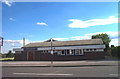
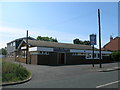
3
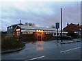
Norton Coronation Club
Working Men's Club on West End Road pictured on a rainy late afternoon in late November.
Image: © Jonathan Clitheroe
Taken: 28 Nov 2015
0.06 miles
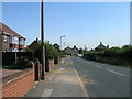
5
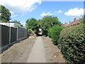
Urban footpath in Norton
This runs between West End Road and Back Lane and links with the footpath towards Smeaton
Image: © John Slater
Taken: 22 Aug 2013
0.08 miles
7
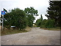
Entering Norton Village from Kirk Smeaton, looking east.
Image: © Bill Henderson
Taken: 7 Sep 2006
0.14 miles
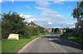
8
View of Cliff Hill, entering Norton from the direction of Kirk Smeaton.
Image: © Bill Henderson
Taken: 7 Sep 2006
0.22 miles
9
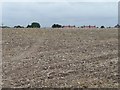
Stubble field on the north side of Cliff Hill
With rooftops of some houses in Norton just visible.
Image: © Christine Johnstone
Taken: 23 Aug 2011
0.22 miles
10

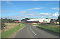
Crop spraying near Norton
The sprayer was having some difficulty working round the electricity pylon and wires
Image: © Graham Hogg
Taken: 30 May 2022
0.23 miles