IMAGES TAKEN NEAR TO
Osprey Close, DONCASTER, DN6 7UN
Introduction
This page details the photographs taken nearby to Osprey Close, DN6 7UN by members of the Geograph project.
The Geograph project started in 2005 with the aim of publishing, organising and preserving representative images for every square kilometre of Great Britain, Ireland and the Isle of Man.

There are currently over 7.5m images from over14,400 individuals and you can help contribute to the project by visiting https://www.geograph.org.uk
Image Map
Images are licensed for reuse under creativecommons.org/licenses/by-sa/2.0
Notes
- Clicking on the map will re-center to the selected point.
- The higher the marker number, the further away the image location is from the centre of the postcode.
Image Listing (20 Images Found)
Images are licensed for reuse under creativecommons.org/licenses/by-sa/2.0
Image
Details
Distance
1
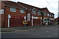
Parade of shops in Mill Lane, Adwick Le Street
Image: © David Martin
Taken: 20 Sep 2015
0.11 miles
2
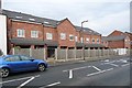
Terrace of houses under construction, Adwick le Street
Each with a garage. On the north side of Fern Bank.
Image: © Christine Johnstone
Taken: 20 Dec 2017
0.12 miles

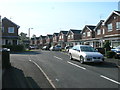
5
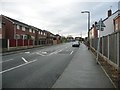
Fern Bank, Adwick le Street
Looking south-west from the junction with Mill Lane and Village Street.
Image: © Christine Johnstone
Taken: 20 Dec 2017
0.16 miles
6
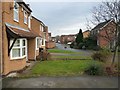
Houses in Falcon Close, Adwick le Street
On the north-east side of Red House Lane.
Image: © Christine Johnstone
Taken: 20 Dec 2017
0.16 miles
9

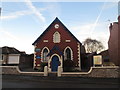
Adwick le Street Methodist Church, Fernbank Mill Lane, Adwick le Street.
Image: © Bill Henderson
Taken: 29 Oct 2006
0.19 miles
10
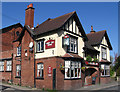
Adwick - Foresters Arms on Village Street
Image: © Dave Bevis
Taken: 16 Apr 2014
0.20 miles