IMAGES TAKEN NEAR TO
The Park, DONCASTER, DN6 7RL
Introduction
This page details the photographs taken nearby to The Park, DN6 7RL by members of the Geograph project.
The Geograph project started in 2005 with the aim of publishing, organising and preserving representative images for every square kilometre of Great Britain, Ireland and the Isle of Man.

There are currently over 7.5m images from over14,400 individuals and you can help contribute to the project by visiting https://www.geograph.org.uk
Image Map
Images are licensed for reuse under creativecommons.org/licenses/by-sa/2.0
Notes
- Clicking on the map will re-center to the selected point.
- The higher the marker number, the further away the image location is from the centre of the postcode.
Image Listing (26 Images Found)
Images are licensed for reuse under creativecommons.org/licenses/by-sa/2.0
Image
Details
Distance
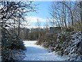
1
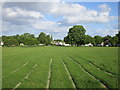
The Park, Woodlands
A running track has been cut into the grass. http://en.wikipedia.org/wiki/Woodlands,_South_Yorkshire
Image: © Jonathan Thacker
Taken: 31 May 2015
0.06 miles
2
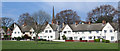
Adwick - part of Woodlands Model Village
This is part of the model village of tied miners houses, designed and built in the early 20th century by the architect Percy Bond Houfton, for the Thellusson family, owners of Brodsworth Colliery. The spire visible behind the houses is All Saints and was built in 1913 and paid for by the Thellusson family. See http://en.wikipedia.org/wiki/Woodlands,_South_Yorkshire for more details.
Image: © Dave Bevis
Taken: 16 Apr 2014
0.08 miles
3
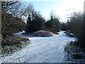
Footpath junction on Roman Ridge
Roman Ridge is the route of the Roman road running north from Doncaster.
Image: © Christine Johnstone
Taken: 2 Feb 2019
0.09 miles
4
Illegal motorcycling notice, off Roman Ridge
At one of the entrances to Brodsworth community woodland.
Image: © Christine Johnstone
Taken: 2 Feb 2019
0.11 miles
5
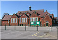
Adwick - Woodlands Primary School
Playground and rear of the west block.
Image: © Dave Bevis
Taken: 16 Apr 2014
0.13 miles
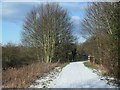
6
Dismantled railway line
At the end of Highfield country park.
Image: © steven ruffles
Taken: 1 Feb 2010
0.13 miles
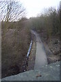
7
Bridge taking Roman Ridge over a former colliery line
Roman Ridge is the route of the Roman road running north from Doncaster.
Image: © Christine Johnstone
Taken: 2 Feb 2019
0.14 miles
8
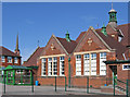
Adwick - Woodlands Primary School
North block. The spire of All Saints Church (see Image) is visible on the left of the photo.
Image: © Dave Bevis
Taken: 16 Apr 2014
0.14 miles
9

Bridge on the Roman Ridge over a former railway to Brodsworth Colliery
Brodsworth Colliery was served by two branch lines. One owned jointly by the Great Northern and Great Central Railways opened in 1908 and passed beneath this bridge. The other was owned by the Hull and Barnsley Railway and opened in 1910.
Image: © Jonathan Thacker
Taken: 31 May 2015
0.15 miles