IMAGES TAKEN NEAR TO
Third Avenue, DONCASTER, DN6 7QE
Introduction
This page details the photographs taken nearby to Third Avenue, DN6 7QE by members of the Geograph project.
The Geograph project started in 2005 with the aim of publishing, organising and preserving representative images for every square kilometre of Great Britain, Ireland and the Isle of Man.

There are currently over 7.5m images from over14,400 individuals and you can help contribute to the project by visiting https://www.geograph.org.uk
Image Map
Images are licensed for reuse under creativecommons.org/licenses/by-sa/2.0
Notes
- Clicking on the map will re-center to the selected point.
- The higher the marker number, the further away the image location is from the centre of the postcode.
Image Listing (14 Images Found)
Images are licensed for reuse under creativecommons.org/licenses/by-sa/2.0
Image
Details
Distance
1
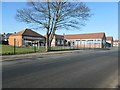
St Joseph & St Theresa's RC Primary School, Woodlands
Just south of the church of the same name.
Image: © Christine Johnstone
Taken: 15 Feb 2019
0.16 miles
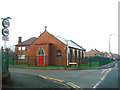
2
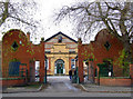
Woodlands, Doncaster
Brodsworth Miners Welfare Institute. Built 1924.
http://flickr.com/photos/riffraff1/3016684716/
Image: © David Hebb
Taken: 13 Dec 2008
0.17 miles
3
Houses by Doncaster Lane, Woodlands East
Image: © Neil Theasby
Taken: 21 Apr 2022
0.17 miles
4
Aagrah Indian restaurant.
Part of a chain based in Shipley.
Image: © Steve Fareham
Taken: 31 Aug 2007
0.18 miles
5

St Joseph & St Theresa's RC Church, Woodlands
At the junction of Welfare Road and Doncaster Lane, with a hall beyond.
Image: © Christine Johnstone
Taken: 15 Feb 2019
0.19 miles
6
St Joseph's and St Theresa's Church, Welfare Street , Woodlands
Image: © Bill Henderson
Taken: 28 Dec 2006
0.20 miles
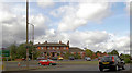
7

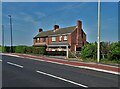
Open space at the junction of Lake Road and Doncaster Lane
The crescent of houses look out to a farm across the main road.
Image: © Christine Johnstone
Taken: 15 Feb 2019
0.22 miles
8

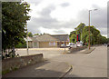
Houses on the north side of Stafford Road, Woodlands
Close to Doncaster Lane [B1220].
Image: © Christine Johnstone
Taken: 15 Feb 2019
0.23 miles
10

Farmland east of Woodlands East
About 10 metres above sea level. Very flat and liable to flood.
Image: © Christine Johnstone
Taken: 15 Feb 2019
0.23 miles